|
Collection of Shallow Water Bathymetry
According to a World Resources Institute study (2001), 20% of the World´s population lives less than 16 miles away from a coastal zone and 39%, or 2.2 billion people, live within 60 miles of the coast. Adequate data within the coastal zone is of great importance for many activities such as coastal zone management, environmental protection and other critical preventative studies such as tsunami modelling and inundation prediction.
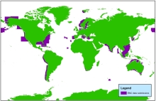
IHO Member States have already contributed substantial bathymetric data coverage for shallow water areas. This has resulted in significant improvements to the GEBCO global grids.
How to contribute Shallow Water Bathymetry?
IHO Circular Letter 36 of 2006 invited Member States to provide low density shallow water bathymetry for their coastal areas. To facilitate the extraction of soundings and contours from ENC cells, a software application was developed and distributed with CL 36 (on CD ROM) and can be requested from the IHB using the Contact form. Only data from ENCs in navigational purpose bands 2 and 3 were requested as these best suited the requirements of GEBCO.
See also IHO CL 11/2016 and see here for more recent information on the coverage contributed to GEBCO.
For more information on the policies for the use and distribution of shallow water bathymetry data, please see IHO Circular Letter 90/2009 (17 December 2009).
Other organizations can also contribute shallow water bathymetry by contacting the IHB using the Contact Form
|