Standardization 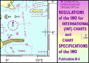 For over 95 years the IHO has consistently worked towards achieving maximum standardization of nautical products, services and survey practices. IHO publication M-4 is an example of an IHO standard that has resulted in the adoption of consistent colours, symbols, nomenclature and general presentation for charts produced by IHO Member Organization. This has made it possible for mariners to use charts compiled by any member organisation, with confidence. For a complete list of all IHO standards and publications, please see the Publications Catalogue. |
| The International (INT) Chart The idea of a common, worldwide chart series (INT Charts) produced to a single set of agreed specifications was adopted in 1971. Under this arrangement, member nations wishing to print their own versions of another members INT charts, may do so by obtaining (by mutual agreement), copies of the necessary reproducible material and printing their own copies. The programme for small scale (1/10 000 000 and 1/3 500 000) INT charts, has been completed and many of the charts at medium and larger scales have also been publised.
|
| Capacity Building and Technical Cooperation With respect to the IHO, Capacity Building is defined as the process by which the Organization assesses and assists in sustainable development and improvement of the States, to meet the objectives of the IHO and the Hydrography, Cartography and Maritime Safety obligations and recommendations described in UNCLOS, SOLAS V and other international instruments. In 2002 the International Hydrographic Organization created a new Committee called the Capacity Building Sub-Committee (CBSC). The principal terms of reference for this Committee are: 1. To assess continuously the hydrographic surveying, nautical charting and nautical information status in nations and regions where hydrography is developing, using an appropriate and agreed methodology. This includes the development and maintainance of IHO publication C-55, "Status of Hydrographic Surveying and Nautical Cartography Worldwide". 2. To cooperate in the establishment and maintenance of close relationships with national agencies and international organizations, which may provide funding or other support to technical assistance projects, and to study the procedures required to access the funds for Technical Assistance available from such organizations. 3. To cooperate with Regional Hydrographic Commissions (RHCs) in the creation of Study Teams or Action Groups to carry out assessment studies in the areas identified by the IHO in its 5-year "Work Programme" and in the subsequent monitoring of the recommendations resulting from those Study Teams or Action Groups' Reports 4. To cooperate in the provision of advice to all maritime nations requesting support to develop hydrographic capabilities, following the implementation of SOLAS regulation V/9. A Capacity Building Fund has been created to provide support for the main categories of capacity building activity i.e. technical assistance, training and education, financial assistance for participation in IHO events and start-up funding for hydrographic elements of projects, as identified in the IHO Capacity Building Strategy. For additional information, see the Capacity Building Sub-Committee section |
| Education and Training Education is essential in creating and maintaining a modern hydrographic service. Over twenty of IHO Member States offer more than thirty technical training programs in hydrography that conform to guidelines established by the IHO. In some instances these programs are offered free of charge while others provide scholarships to those attendees that demonstrate the need. In cooperation with the Fédération Internationale des Géomètres (FIG), and the International Cartographic Association (ICA), a comprehensive set of Standards of Competence for hydrographic surveyors and nautical cartographers have been drawn up, together with appropriate syllabi for the guidance of universities and teaching establishments throughout the world. An International Board supervises the application of these standards with a view to achieving internationally recognized qualifications in the hydrographic profession. The Board reviews the training syllabi of world wide educational institutions, and awards international certificates of recognition to those courses which have achieved the required minimum standards of competence. Three important publications relating to education and training include:
These publications are available from the "Standards and Publications > Downloads" section of the IHO website |
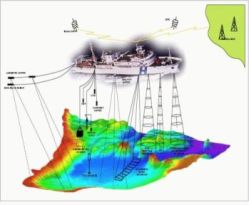
| Hydrographic Surveys IHO Member States have a fleet of about 400 hydrographic survey vessels, numerous hydrographic launches, support helicopters, and aircraft equipped with laser survey equipment. Surveys include bathymetry (soundings), land topography, and oceanographic measurements (e.g. tides, currents, waves). Soundings (depth measurements) are primarily acquired using single and multi beam ship mounted echo sounding equipment (sonars), however, in shallow coastal waters, aircraft mounted laser echo-sounding equipment, is also being used for the rapid collection of bathymetric data. Most survey data is collected in digital form which facilitates the creation of data bases that are used to generate navigational products such as nautical charts, bathymetric maps and customized GIS products.
|
| Charts and Nautical Documents One copy of every new INT Chart and publication produced by a Member State is archived at the International Hydrographic Bureau. Under the IHO Convention, free exchange of single copies of charts and nautical publications among Member States is fostered. |
|
External Liaisons The International Hydrographic Organization works with a wide spectrum of International Organizations, Industry Stakeholders and other important associated communities. This section provides information concerning these External Liaisons.
|